Alta Via I - August 2022
- Peter Goodair

- Jan 3, 2024
- 19 min read
Updated: Apr 3, 2024

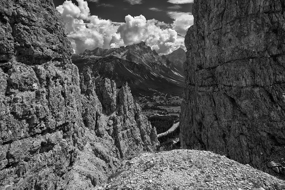
Dramatic Peaks Above Ciadin del Loudo
Along with stunning scenery with colossal limestone peaks guarding sweeping verdant valleys and some of the best food and wine to be found in mountain huts there is much to love about the Dolomites. This, together with the warm hospitality of the Italian people, and a fascinating history, make this region a favourite for hikers and trekkers.
I had driven through the Dolomites many years earlier and remember how I struggled to keep my eyes on the road when, taking a bend, the next dramatic limestone peak would appear causing me to stare in wonder. I was therefore delighted to visit the region again and to be able to explore it more closely on foot. The arrival base for the trek was Cortina and the plan was to arrive a couple of days early to enjoy a couple of local day hikes before setting of on the AV1 trek.
We would be guided on the AV I trek by Emma Jack of Cloud 9 Adventures. Prior to the trek Tony, David and I planned a couple of preparatory day hikes in the vicinity of Cortina.
Day Hike 1 - Passo Tre Croci, Lago di Sorapis. Passo Tre Croci
Distance 17.5 Km; Ascent 739M; Descent 754M; Highest Elevation 2289M
The weather when we set off from the car park at Passo Tre Croci was very encouraging with some wispy light cloud breaking up the blue sky. The forecast for later in the day however, was not so favourable with thunderstorms likely. We had decided to take the easy trail (215) to Lago Sorapis as this would enable us to enjoy this local beauty spot and then to choose whether to simply retrace our steps or, if the weather held up, to take the more adventurous trail rising below the steep crags of Zimes Del Cardin Del Loudo. From there we could take a very steep scree descent and join the trail to complete a circular hike back to Passo Tre Croce.
With the exception of the very high number of people on the trail the hike through the dense woods to the lake was unexceptional. The lake is obviously a popular destination for Italian visitors and the presence of Rifugio A Vandelli al Sorapis close to the lake is an added attraction. The trail was in good condition and by the time we reached the lake we had only ascended 120M. The stunning blue of the lake contrasted strongly against the backdrop of the limestone cliffs of Circo del Sorapis rising over 1000M above the lake. People were dotted all round the lake sitting on rocks posing for selfies or enjoying picnics on patches of grass by the water's edge.
Lago Sorapis

The tables outside the rifugio were full and so once we topped up water we decided to head up the steep trail towards Ciadin Del Loudo. This required us to retrace our steps back on trail 215 for 20 minutes or so before taking trail 216 breaking off on the left. This trail is obviously not used anything like as frequently as trail 215 because it was heavily overgrown in places requiring us to force our way past thick branches. The air was becoming very humid suggesting that the storms that had been forecast might be heading our way. After much perspiration and an hour of fairly steep ascent we emerged on the open ridge above Ciadin del Loudo. From here we could see that the cloud had built up somewhat but the storm did not feel imminent. We therefore decided to press on at least to the steep scree descent and to make a final decision then on whether to descend the scree. We reckoned that if the worst came to the worst we could simply retrace our steps by descending trail 216 and returning to the pass on trail 215 that we had taken to the lake although this would increase the return distance by about a third. I was particularly concerned about the prospect of descending scree in pouring rain should this occur.

Monte Cristallo from Forc. Marcuoira
Although the cloud was building quite noticeably we could not pass up on the opportunity to take a 20 minute break to admire the fabulous views from the ridge. The trail from here to the start of the scree descent was obvious and straightforward. Within no time we were staring down the scree face and lengthening poles to provide extra stability. According to my Garmin records the descent of the scree took about 45-50 minutes and we were all relieved to be back on a recognisable trail.
From here the route back to the pass was straightforward. The air was getting very muggy and it felt as though a storm was about to break. We were all relieved to be off the scree before any rain had fallen. As we walked through the woods there would be occasional views across the valley to the stunning Pomagagnon Ridge.

Storm Cloud Above Pomagagnon Ridge
The view through the trees to the crags on the Pomagagnon Ridge took my breath away. It occurred to me for the first time that in places the Dolomites are reminiscent of the grandeur of Yosemite Valley. The white limestone mirroring the pale, admittedly much smoother, granite of Yosemite. Similarly the distance between the limestone monoliths either side of wide, sweeping, verdant valleys reminded me of the way in which the granite monoliths of El Capitain and Half Dome tower above the valley in Yosemite. It is this that prompted me to process some of my raw images in mono in an attempt to attain the dramatic effect pioneered by the great Ansell Adams.
Shortly after I snapped this view of the ridge there was a loud crack of thunder and it began to rain. Sensing that we were not too far from the hotel at the pass where we had parked Tony and I began to run as the rain became heavier. Sure enough within 5 or 10 minutes we were safely sheltering under umbrellas at the bar beside the hotel. David arrived fully clad in rainwear about 15 minutes later and we were soon nursing beers and
reliving aspects of a great first day in the Dolomites.
Day Hike 2 - Descent from Tofana di Mezzo (3244M) and Return to Cortina
Distance 9.3 Km; Ascent 25M; Descent 1168M; Highest Elevation 2445M
The hike to Lago Sorapis had been a reasonable effort and so the plan today was for an easier day, to get high, admire the view and then descend and return to Cortina. The cable car across the valley to Monte Tofana looked particularly appealing but unfortunately that morning the peak was covered in cloud. On reaching the ticket office at the foot of the mountain we decided to buy tickets only as far as to the middle station. What was the point in paying to be in thick cloud and in any case we planned to descend from the middle station using a marked trail (407). By the time we arrived at the middle station the cloud had lifted and the peak was bathed in bright sunshine. Fortunately, the cable car attendant at the middle station was able to sell us tickets for the final stage of the ride. This dropped us approximately 50 or 60 metres below the summit. The light was wonderful and we needed no persuading to hoof it up the path and then to make the easy scramble from the end of the path to the summit.
View from the summit of Tofana Mezzo (3244M)

The view from the top had been well worth it. The rocky peak enjoys an airy stance and affords excellent views in all directions. We were to look up to this peak a few days later on the AV1 although we didn't appreciate this when standing on the summit! Having had our fill of the wonderful views we descended the short way to the top station and took the cable car back down to the middle station. Once we had located the relevant part of the trail the descent was clearly indicated and we were soon on our way down the mountain.
Initially the descent was plain sailing. We were walking on scree but this had been pummelled into the mountain by piste machines used to maintain the ski runs in winter. Plus the gradient was relatively benign initially, but this was soon to change. Quite suddenly the angle of the descent steepened markedly and the scree became increasingly loose. We descended with caution at this point thinking that the scree would soon become less loose. Unfortunately this was not so. The angle remained steep and the scree became even looser the closer we got to the end of what was obviously a black ski run in the winter season.
Scree Descent from Tofana

As we approached the end of the scree we were asking one another for advice on the best line to take to avoid a long slide. At one point I ventured into a cluster of sapling trees thinking their roots would have helped to stabilise the scree but if anything this just seemed to make matters worse.
Fortunately it was now not long before the slope paused at a point where a track passed at right angles. There was a little shade and some grass to enable us to take a well earned break and enjoy the fabulous cheese and ham rolls we had bought in Cortina that morning.
Once we had finished with our packed lunches we continued along the obvious trail back to the town. It was impossible to stop gazing back at Tofana and checking the various stages of the scree route we had taken down. Apart from that the return to Cortina was unremarkable with the sole exception of the spectacular view of the town that greeted us when about a kilometre or so away. We had been walking across a meadow strewn with alpine crocuses in bloom as dusk was falling over Cortina. It had been another great day in the Dolomites!

Dusk Falls Over Cortina
Pre trek briefings and dinners are usually most informative and not to be missed. However, as with life in general, it pays to be aware of the fallibility of basing assumptions on first impressions. It is obviously an opportunity to begin to get to know fellow trekkers and, more importantly, the guide. For me, however, it is the practical information and guidance offered by the guide that is most critical on such occasions. Would it be possible to top up water en route? Would access to luggage be possible at any stage? What facilities will be available in the huts e.g. showers, dorms and meals? This trek was no exception. The detailed trip notes had been circulated well in advance and I had sensed from these that this trek was going to kick off with a bang with 22km to be hiked on the first day with over 1500M of ascent and 1000M of descent. The world was just coming out of hibernation from the Covid pandemic and this had resulted in some difficulties with booking of accommodation for the trek and this in turn had made it necessary to stretch the first day more than would typically be necessary on the AV1. I felt this would be within my limits but was concerned about the implications for one or two others in the group who openly admitted that this would be new territory for them. I had trekked with Emma, the guide, before and had complete confidence in any judgement that she might make whether in the organisation of the trek or en route.
AV1 Day 1 - Lago di Braies to Rifugio Laverella
Distance 22km; Ascent 1500m; Descent 1020m
Everyone sensed the day was going to be no gentle introduction to the AV1 and so there were no latecomers for the two minibuses that had been arranged early that morning to ferry us to the start point at Lago di Braies at the nothern end of the route. The teal coloured lake was bathed in early morning mist and the air felt distinctly damp as we emerged from the buses to gather rucksacks and poles from the trunk. Judging from the size of the car park, the nearby hotel/restaurant and the number of people already milling around the lake is obviously a popular tourist attraction. The trail commenced with a gentle stroll around the shore of the lake before beginning to make a gentle ascent through the woods. After half an hour or so we were trudging in a stretched out single file up glacial moraine formed from the white limestone that we were to see so much of over the course of the week. After about an hour and a half, having gained some height, a clearing in the trees revealed a lovely view back down to the lake in the distance. However, as is so often the case, the camera was not able to do justice to the fabulous view.
After 3 hours or so we were no longer on the wooded slopes above the lake but hiking along gentler terrain affording fabulous views of the limestone scenery towering above and in the distance. As already mentioned, the panoramas in the Dolomites reminded so much of the majestic vistas I recall from my visit to Yosemite so many years before.

Nabiges Loch, with cliffs of Monte Muro (r); Day 1 Alta Via, Dolomites
The ascent towards the pass at Porta Sora il Forn had been quite steady and not too arduous and before too long we were heading along easier terrain towards Rifugio Pederu. Arriving at Pederu, with its enormous car park, we were all grateful for an opportunity to stretch out on the ample grass lawn surrounding the mega hut which was doing a roaring trade with Italian day trippers. Some of us had wished that this would have marked the end of the first day, as it so often is for trekkers on the first day of the AV1.
From Pederu the wooded valley soon gave way to limestone slopes and warm sunshine. That said, the ascent along the Fanes Valley was steady and not too steep.

Ascending the Fanes Valley
Within a short while we could see Rifugio di Fanes, the signal confirming that our destination at Rifugio Laverella was but half an hour ahead of us. It had been a long, first day and many of us were more than ready to sink a few well-earned beers!
AV1 Day 2 - Rifugio Laverella to Lagazuoi and the Passo Falzarego
We set off at the agreed time of 8am in warm sunshine. The gradient and path for the early part of the day were very gentle which was just as well as my stomach was feeling quite queasy. As if by telepathy Emma mentioned after an hour or so that for anyone requiring a pee break it would be advisable to do this within the next 30 minutes as opportunities after this would be few and far between. I am rarely troubled by such issues on treks but I suspected that the tap water in Cortina had not been the best and therefore took the opportunity to veer off the trail behind some rocks to see if I could get rid of whatever was ailing me. After a brief interlude I was soon back with the gang and moving along more happily.
After almost 3 hours we arrived at the dramatic pass of Forcella di Lech. The pass revealed itself all at once in the blink of an eye and has to be one of the most dramatic alpine passes I have ever seen. In a single view before us were the steep cliffs on either side of the pass; the steeply descending path that was being carefully negotiated by a few hikers before us; the beautiful lake way below at the foot of the descent and the sky on the horizon above a towering peak beyond the lake. It took several minutes to take in all of the elements of the scene. It also took me a little time to frame the single shot that would capture the scene and the result is below.

Descent from Forcella di Lech with Lago di Lagazuoi below
At first sight the angle of the descent seemed quite intimidating but unless one suffered from vertigo it was nothing to be feared. The path was stable and contained numerous zig zags so that the height lost at each turn was relatively small. Hiking poles provide great assurance on such descents and, having used them ever since my early 50s I would never be without them! Happily everyone made it down without any issues and in next to no time we were basking in the sunshine by the lake shore enjoying our packed lunch. The view back up to the pass and neighbouring cliffs from the lake held my gaze for much of the time over our lunch break (see next image), only to be disturbed by the sight of a few young German hikers stripping off their hiking garb to plunge in to the inviting water, shrieking as they did so.

Cliffs and Pass at Forcella di Lech
It would have been lovely to spend longer at the lake but after an hour, before muscle stiffness had an opportunity to take its toll, we were off again taking the path that is clearly visible beyond the lake in the photo above. The heat had built up over the course of the day and it was becoming quite humid too. I decided that as this was to be the final pull of the day there was no need to rush at it and settled into a steady rhythm towards the rear of the group. For some sport a couple of hikers in the group had had a wager on whether one of them would make it to he cable station and rifugio/restaurant on the ridge at Lagazuoi (2752M) within 50 minutes! Before the final approach to the rifugio the trail revealed superb vistas left and right including the wonderful sight of Tofana on whose peak we had stood a few days earlier.

En route to Lagazuoi
The final approach to the rifugio contained a number of defensive installations created by the Italian forces during the First World War. It was a pleasure to bask on the terrace of the rifugio in the sunshine with a beer knowing that most of the hard work had been done on another wonderful day in the Dolomites. However, we were sorry to learn that Cindy & Pete, a lovely Australian couple, had decided that their trek was done. They had found the first two days to be too demanding to the extent that they had not been able to enjoy the magnificent scenery. They would nevertheless remain in the area and join us at the end of trek dinner back in Cortina. We took the short cable car down to the valley where taxis had been requested to pick us up and drop us off at the Hotel La Baita where we would stay the night.

After a couple of quite demanding days the hotel was the perfect place to recover and recharge batteries. With lovely home cooked Italian cuisine and an extensive wine list we soon forgot aching limbs and sharing stories from the trek and previous adventures.
Arrival at Hotel la Baita, Col di Lana
AV1 Day 3 - Rifugio Lagazuoi to Rifugio Averau
Distance 4.5km; Ascent 445m; Descent 134m
After two quite gruelling days the third day was set to be relatively easy commencing with a taxi ride to the cable car station to take us back back up to Lagazuoi. Emma had arranged for us there to join a guided tour of the wartime defensive installations created by the Italians during the First World War. While the man giving the tour was fetchingly dressed in military uniform from the wartime era the event suffered somewhat from the fact that he gave very little of his spiel in English. David and I soon decided to abort in favour of exploring the summit ridge and the wonderful view over to the Marmolada peak (3,343M) on which the last remaining glacier in the Dolomites could be seen. Rising global temperatures caused a major part of the glacier to collapse just a month or so before our visit. Eleven hikers were sadly killed by the resulting avalanche.


View fom Lagazuoi to Marmalada Guided Tour on Lagazuoi
After the guided tour the majority of the group took a path through the tunnels created in the mountain during the First World War while David and I continued to take photos on the summit ridge before taking the cable car down to the road where we could grab a coffee while waiting for the others to arrive.
Once we had all assembled below at the cable car station it was time to set off. A path veering off the road to the right took us across some pastures and in next to no time we were all seated around a table at a nearby restaurant that looked as though it would have a roaring trade in the ski season. The menu was extremely tempting causing me to have 3 courses with beers - not the best thing to do on a trek! After the gentle morning and a very pleasant lunch it was time to get down to some serious hiking. Once across the field we entered woods and began ascending for about an hour or so before we emerged from the trees into rocky terrain with a very good path.
It did not seem that long before I sensed we were approaching our destination at Rifugio Averau. The cloud had begun to build and the light was becoming interesting. The shot below was taken on our approach to the hut.
Approach to Rifugio Averau

As the hut came into view I could see that the light on Monte Averau was becoming very interesting, showing every nook and cranny of the mountain and the strata formations in the rock. On arrival at a hut the priority is to get checked in, to claim your bunk and dump your bag.
My priority above all else was to drop my bag on a bunk bed, grab my camera and get outside as quickly as possible because I sensed that the light was changing second by second. I was not to be disappointed. The image below was taken as soon as I got back outside and it was clear that storm cloud was rapidly building. Thunderstorms had been forecast all week and we had somehow evaded them but this one was going to hit us!

Dramatic Light on Monte Averau
Having caught all the shots I thought I would need to get at least one good one I began to amble around the hut looking for other opportunities. At the side of the hut I encountered a young couple sitting side by side with drinks admiring the wonderful panorama ahead as the sun was going down. Their silhouettes added perfect foreground interest to the shot. I was so pleased with it that I gently disturbed them to share the image captured in my camera. They smiled approvingly.

Admiring the View from Rifugio Averau
Rifugio Averau enjoys a fabulous location on a small plateau in the shadow of neighbouring Monte Averau. With the exception of the rather solemn natured Guardien, the staff were very pleasant and helpful, particularly in guiding some of us through their impressive wine list. We ate and drank well that night and bore all the signs of it the following morning! We were also relieved to be inside when the thunder storm that had been threatening us for a couple of days struck later that night.
AV1 Day 4 - Rifugio Averau to Rifugio Staulanza
Distance 17.6km; Ascent 572m; Descent 1189m
After a typical, fairly frugal mountain hut breakfast we gathered packed lunches and made an early start. Fortunately for us the storm that had arrived while we were safely inside the hut overnight had long passed leaving another bright day to enjoy the amazing scenery. We were soon away from the rocky terrain surrounding Averau and traversing pleasant meadows before arriving at Forcella Giau (2,360M) passing Mt Genera on the right. The trail continued to undulate gently across meadows with rock features often towering above.


Lush Meadows & Valleys Towering Crags
The gently undulating terrain continued for a while before the short ascent to Forcella Ambrizzola. From here we began a long descent heading south east before eventually arriving at Rifugio Citta di Fiume with fabulous views to the peaks of Pelmo with height exceeding 3000M. The Rifugio was an excellent pit stop knowing that our destination, Rifugio Staulanza, was not too far away and the trail was predominently downhill!


Pelmo Approach to Rifugio Staulanza
Arrival at Rifugio Staulanza situated on the road at Passo Staulanza was a very pleasant surprise as the scene that greeted us was more akin to that of a very welcoming hotel and restaurant. Moreover, once inside we were treated to very well appointed rooms rather than large soulless dormitories that are the norm in the more remote mountain huts. To top it all the refuge also offered a wellness centre that includes a Finnish sauna to soothe all those aching limbs.
In keeping with the excellent facilities in the refuge we ate extremely well with fine Italian cooking and generous portions. Those of us who like to round off the day with a few draught beers or very quaffable wine were in our element. I have been informed that visitors to my site find the blogs helpful for planning their own adventures. With this in mind I thought it might help to share the web address for this lovely hotel - https://Staulanza.it/index.php
AV1 Day 5 - Rifugio Staulanza to Rifugio Vazzoler
Distance 17.5km; Ascent 1028m; Descent 992m
This was to be another solid day of hiking with over a thousand metres of ascent. The weather was set fair when we set off with an early start. The trail initially followed the road descending from the pass before veering off and before long proceeding through woodland in which there was evidence of recent logging activity. After a couple of hours the trail emerged once again into the familiar rocky terrain of the dolomites offering views to distant peaks.

Approach to Lago Coldai
After another half an hour or so we arrived at the lovely teal coloured Lago Coldai. Looking down at the lake I could see hikers dotted around it which was not surprising for such a lovely location.

Lago Coldai
After about another the trail arrived below the stunning cliffs of Civetta, one of the best playgrounds for climbers in the Dolomites and is unique in having a vertical drop of over 1000M along its 4km length. We passed a lone rock facing Civetta on which is mounted a moving plaque dedicated to the memory of Marco Anghileri, a fine Italian climber who sadly passed away in 2014, aged 41, attempting a solo winter ascent of the Central Pillar of Freney on Mont Blanc. Marco had recorded a number of first ascents of difficult routes on Civetta and clearly loved this area.

Cliffs of Civetta
Before we had passed very far along the trail facing the Civetta massif Emma paused to consult us on whether we wished to take the opportunity of adding a small variant to the planned itinerary. This entailed a short deviation off the trail north to visit Rifugio Tissi and a climb of 150M. With an eagle's nest location on a ridge facing Civetta it was difficult to resist this opportunity and it would make the perfect place to stop to eat our packed lunches. Passing quite close by to a penned flock of sheep with an attendant but calm pastou dog we headed up the slope towards the rifugio. The view on arrival over to Civetta was stunning and we soon settled down with our lunch packs taking it all in. Unfortunately a brief rain shower forced us to seek shelter. Afterwards we ventured outside once again to explore the view from the very top of the ridge just above the rifigio.

This airy stance gave a great view of the panorama to the north west and also of Lago di Alleghe directly below. Having drunk in the fine view to our fill and with the sun shining once again we were happy to beat a retreat to the AV1 trail.
View from the ridge above Rifugio Tisi
Rifugio Tisi was to be the final high point of the day and the initial descent to Forcella di Col Rean was straightforward as was the remainder of the trail to Rifugio Vazzoler. The sight of the rifugio on arrival located in a pleasant woodland glade was quite pretty with geranium bearing window boxes adorning each window. However, the interior of the rifugio merely served to illustrate how much we had been spoilt with the accommodation so far. Emma had given some warning of the sudden drop in the standard of accommodation that we would experience on our last three overnight stays on the trek and this certainly lived up to the low expectations she had set.
I recall that our group was assigned a dormitory in an annex to the rear of the

building which was extremely basic by comparison with our earlier accommodation. The showers were not very clean and the lavatory in an outbuilding was one of the most basic of basic facilities I have experienced anywhere. Suffice to say you would not wish to use it without a head torch!
Rifugio Vazzoler
AV1 Day 6 - Rifugio Vazzoler to Rifugio Carestiato
We set of along the track through the woods and within 15 minutes a break in the trees revealed a stunning view of the cliffs below Cima di Busazza and Castello di Busazza forming part of the Civetta massif.

Early Morning Mist in the Dolomites
...to be continued


Comments